Path: Admin > GIS > Map Indicators
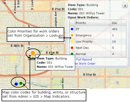
Use the Map Indicators window to set the color code that identifies an item on the map. This is different from the priority color for work orders. Priorities are established in Organization > Lookups.
The following graphic illustrates the application of Map Indicator and Priority colors.

Use the Map Indicators window to set up the criteria that determine the colors displayed on the Map View. The colors can be used to alert viewers about the degree of urgency based on open work orders at locations on the map.
The criteria for each line consists of both the priorities assigned to the line as well as the designated Count, i.e., the minimum number of work orders assigned a priority that triggers use of the color.
For example, if the color for line 1 is Red and has a selected Priority of Next Day with a Count of 4, WebTMA would show a red dot if there were four or more open work orders at the location with a priority of Next Day. If the number of work orders is less than four, WebTMA shows the next color that meets the criteria. If no lines meet the criteria, WebTMA uses the default color.
Each color line can have one or more priorities associated with it.
WebTMA looks to the first line in the Order column, i.e., the line assigned number 1, and continues down the list to determine the display color.
The Count column shows the minimum number of open work orders with the selected priority or priorities that permits use of the color.
The map reflects a dot on the map in the color of the first line where the total number of qualifying open work orders meets or exceeds the Count value. If no lines are matched, the default color is used.